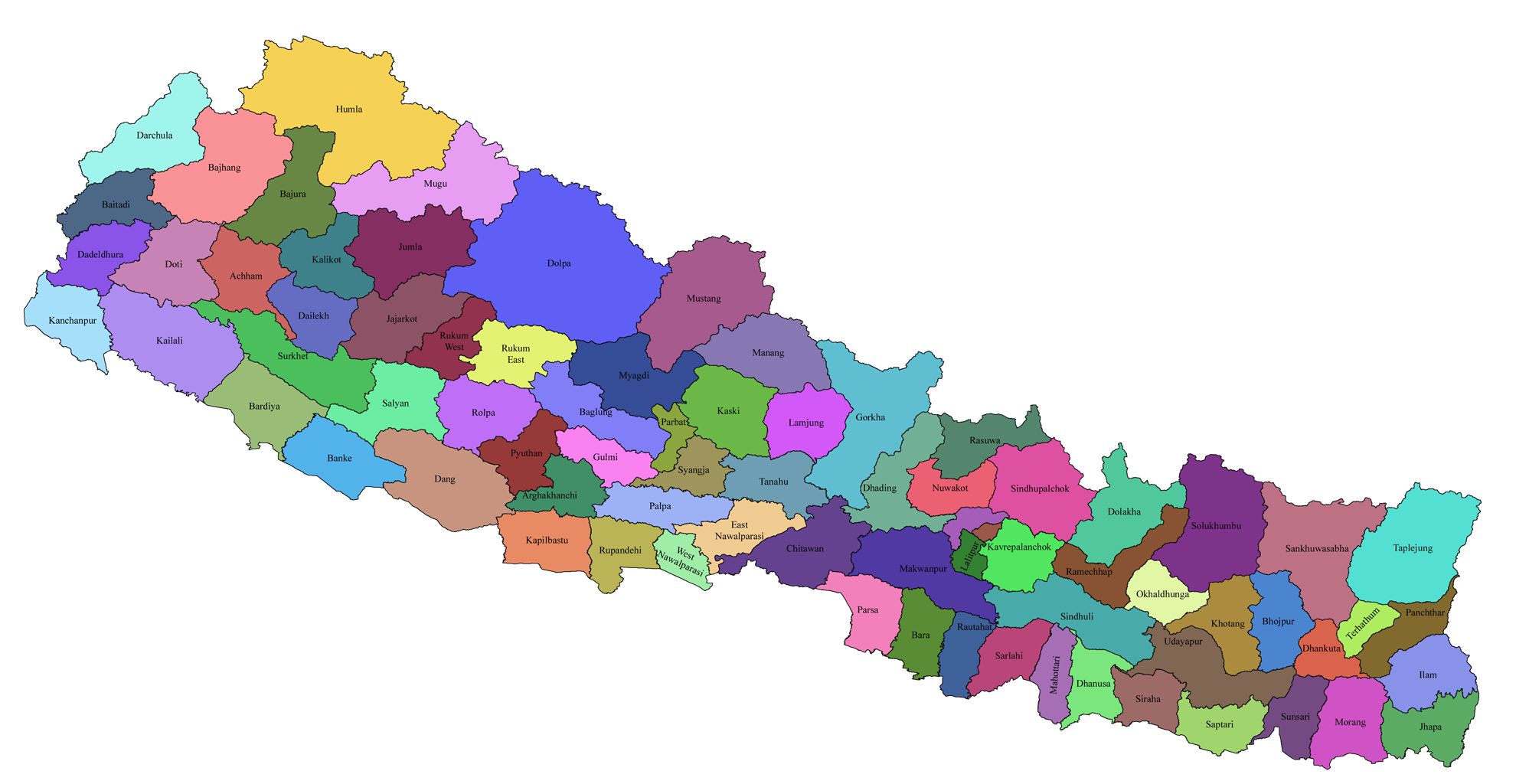
Search Map

Various Types of Maps of Provinces, Districts & Municipalities
Constituency Map of Udayapur District of Nepal
Udayapur District had 2 Federal Constituencies and 4 Provincial Constituencies with total registered voters - 317,532 in 2017 Election. Udayapur had total population 175,461 as per 2011 Census. (Source: Nepal Election Commission)
Read More
Constituency Map of Taplejung District of Nepal
Taplejung District had 1 Federal Constituencies and 2 Provincial Constituencies with total registered voters - 127,461 in 2017 Election. Taplejung had total population 70,778 as per 2011 Census. (Source: Nepal Election Commission)
Read More
Constituency Map of Syangja District of Nepal
Syangja District had 2 Federal Constituencies and 4 Provincial Constituencies with total registered voters - 289,148 in 2017 Election. Syangja had total population 191,253 as per 2011 Census. (Source: Nepal Election Commission)
Read More
Constituency Map of Surkhet District of Nepal
Surkhet District had 2 Federal Constituencies and 4 Provincial Constituencies with total registered voters - 350,804 in 2017 Election. Surkhet had total population 184,399 as per 2011 Census. (Source: Nepal Election Commission)
Read More
Constituency Map of Solukhumbu District of Nepal
Solukhumbu District had 1 Federal Constituencies and 2 Provincial Constituencies with total registered voters - 105,886 in 2017 Election. Solukhumbu had total population 61,746 as per 2011 Census. (Source: Nepal Election Commission)
Read More
Constituency Map of Siraha District of Nepal
Siraha District had 4 Federal Constituencies and 8 Provincial Constituencies with total registered voters - 637,328 in 2017 Election. Siraha had total population 331,596 as per 2011 Census. (Source: Nepal Election Commission)
Read More
Constituency Map of Sindhupalchok District of Nepal
Sindhupalchok District had 2 Federal Constituencies and 4 Provincial Constituencies with total registered voters - 287,798 in 2017 Election. Sindhupalchok had total population 198,681 as per 2011 Census. (Source: Nepal Election Commission)
Read More
Constituency Map of Sindhuli District of Nepal
Sindhuli District had 2 Federal Constituencies and 4 Provincial Constituencies with total registered voters - 296,192 in 2017 Election. Sindhuli had total population 168,247 as per 2011 Census. (Source: Nepal Election Commission)
Read More
Constituency Map of Sarlahi District of Nepal
Sarlahi District had 4 Federal Constituencies and 8 Provincial Constituencies with total registered voters - 769,729 in 2017 Election. Sarlahi had total population 366,605 as per 2011 Census. (Source: Nepal Election Commission)
Read More
Constituency Map of Saptari District of Nepal
Saptari District had 4 Federal Constituencies and 8 Provincial Constituencies with total registered voters - 639,284 in 2017 Election. Saptari had total population 331,462 as per 2011 Census. (Source: Nepal Election Commission)
Read More
Constituency Map of Sankhuwasabha District of Nepal
Sankhuwasabha District had 1 Federal Constituencies and 2 Provincial Constituencies with total registered voters - 158,742 in 2017 Election. Sankhuwasabha had total population 96,657 as per 2011 Census. (Source: Nepal Election Commission)
Read More
Constituency Map of Salyan District of Nepal
Salyan District had 1 Federal Constituencies and 2 Provincial Constituencies with total registered voters - 242,444 in 2017 Election. Salyan had total population 125,256 as per 2011 Census. (Source: Nepal Election Commission)
Read More
Recent Comments
    Archives
    Categories
    • No categories
    Comments
    All comments.
    Comments